
By Pam Marcum
Our long-term monitoring programs collect a lot of data and it is very easy to get lost sifting through it all during analysis. There are millions of small questions that we can answer and specific patterns we can pick out, but what about the ‘bigger picture’ questions? Questions like “What ecological response does climate change have on coastal ecosystems?” or “How do salt marshes respond to sea level rise?”

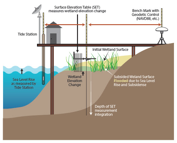
One of the challenges we face when trying to look at the ‘big picture’ is how to relate the different monitoring programs to one another to answer those questions. We can find correlations in the data, but it is difficult to make definitive statements from those relationships alone. The NERRS has developed the Sentinel Site Application Module 1, or SSAM-1 for short, to directly link the data collected from the water quality and salt marsh monitoring programs. When fully implemented, SSAM-1 uses the water quality monitoring instruments to track water levels and pairs them with data on vegetation species shifts and sediment elevation change over time at the nearby salt marsh monitoring stations. By linking these two data sets we can evaluate how the marsh is responding to changing water levels. Cool, right?
Marsh resilience in the face of climate change is a hot topic in coastal research today. There are three primary scenarios that researchers think might happen to marshes in response to rising sea levels:
- There is enough sediment input to elevate the marsh to keep up with rising water levels;
- The marsh will migrate inland displacing uplands habitat;
- The marsh cannot keep up with rising water levels and the marsh will drown- a complete loss of the habitat.
The SSAM-1 program will help researchers better evaluate which of those three scenarios is likely to occur at a local/regional scale. This information is extremely important for citizens, land managers, and governments to make informed decisions when planning for the future.

Here at the GTM Research Reserve, we plan to implement the SSAM-1 at two locations- one in the northern component and one in the southern component of the reserve.
We will be chronicling our journey through the SSAM-1 implementation process, so stay tuned for more!
