
By Shannon Dunnigan

Hurricane Matthew has increased to a category 4 hurricane as it makes it’s way by Freeport, Bahamas. Almost all of Florida’s eastern coastal counties have had mandatory evacuations in preparation for the incoming Matthew. Hurricane warnings have been extended northward into South Santee River, South Carolina. A “Hurricane Warning” means that hurricane conditions are expected within 36 hours before the first anticipated occurrence of the tropical-storm-force winds. Check out the time-lapse video below taken from the International Space Station!
At the moment, the path of Hurricane Matthew is likely to parallel parts of the East Coast instead of making landfall (though some models do have tracks with it making landfall near Melbourne, Florida). How a tropical storm tracks along a coast, with other factors such as its intensity and forward speed, as well as, the size and shape of the coast, can have an affect on the severity of storm surge, rainfall, wind speeds, potential flooding and how far these impacts may be from the coast.

Direct landfall increases potential storm surge, but by skimming the coastline, not only is there lower storm surge potential in one particular location, but the hurricane’s most intense winds lie on part of the coast and the impacts from wind and rain are more widespread. Without making landfall, though, the hurricane conditions are likely to impact more coastal residents.
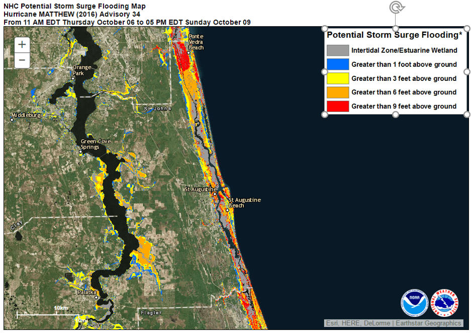
The National Hurricane Center has a interactive graphic that highlights areas for potential storm surge flooding. The map has layers and allow for a user to zoom in and out to see areas in further detail. At present, many of St. Johns County coastal areas have potential storm surge greater than 3 feet above ground. There is even a prototype storm surge warning map. Check it out!
The GTM has been closed today and will be tomorrow as well. Yesterday, preparations were made to move the GTM fleet to safer ground and to get the building set up for hurricane conditions. Many of us NERRds have evacuated our coastal homes for higher ground.


Some of us are showing our NERRd-y side and have been watching the data as it rolls in from our telemeter-ed, real-time weather station or setting up mini weather stations of our own! From our weather station, you can see barametric pressure dropping and wind speeds increasing as Matthew gets closer and closer to Florida.


You can look up the data for yourself by going to nerrsdata.org!
Stay safe and dry everyone!
